
Federal Spatial Data Infrastructure FSDI
The Federal spatial data infrastructure (FSDI) is the part of the NSDI within the Federal administration itself and whose implementation represents the specific task of the two COGIS Processes «Geoinformation coordination and steering» and «Spatial Data Infrastructures (SDI) Development and maintenance».
The pillars of the FSDI
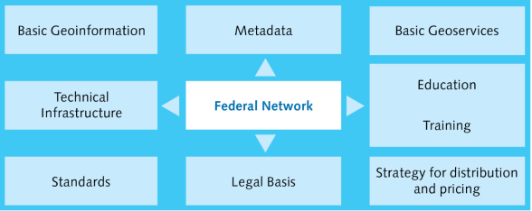
The nine pillars of the FSDI in support of the NSDI:
- 1. Federal Network
advise Federal organisations on the whole field of geographical information, coordinate and take part in GIS projects, manage the GCG secretariat, set up information groups - 2. Basic Geoinformation
compile the catalogue of basic geodata in accordance with Federal legislation
Catalogue of basic geodata in the ordinance on Geoinformation (in German) - 3. Metadata
make the geocat.ch software available for both the recording and search of metadata and maintain the corresponding GM03 data model
Metadata-Application geocat.ch - 4. Basic Geoservices
make available networked applications to enable the use of electronic services in the geodata field and provide Internet access to them
Web Services (SOAP, WMS) - 5. Technical Infrastructure
create a network of databases using common standards and protocols so as to ensure compatibility and interoperability of data and services - 6. Technical training / research
provide courses on geographical information for Federal personnel and support research projects at the various technical universities and the two Federal Institutes of Technology - 7. Guidelines and standards
develop standards covering the whole field of geographical information at both the national and international level and make tools and assistance available to support the application of these standards
The Geolanguage INTERLIS
Metadaten GM03 - 8. Legal Basis
formulate legislation on geographical information including the relevant ordinances
Geographic Information Law GeoIG - 9. Pricing strategy
harmonise and simplify the directives on pricing and distribution which vary widely across the Federal administration